2.11. Reports and suggestions for inaccuracies on the map
Yandex Maps users can report inaccuracies that they find (see the Support section).
You can view these reports and fix the related inaccuracies in Yandex Map Editor.
For examples of handling inaccuracies, see Section 2.11.4 Examples of inaccuracy management
You may also view and verify suggestions on possible inaccuracies based on data analysis. For example, a user may conclude that a speed limit was specified incorrectly based on information from dashcam images or the Yandex Map Editor app.
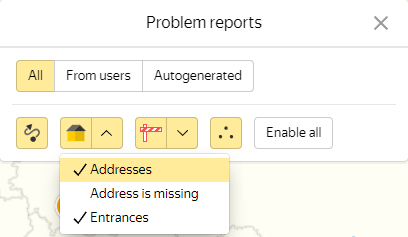
2.11.1. Displaying and filtering messages
To fix an inaccuracy or verify an inaccuracy recommendation, do the following:
-
Click Correct problems reported by Yandex users
 .
. -
The Inaccuracy reports panel will open:
Note
To change your inaccuracy display filters without turning off the inaccuracy layer altogether, click Inaccuracy report settings
 .
.If you have permissions to handle inaccuracies by area, you'll also see the
 (Show/Hide filters) button that shows or hides the inaccuracy filter panel. Hiding the panel expands the area displaying the list of inaccuracies.
 -
Choose the appropriate filter based on the report source:
-
All ─ displays all inaccuracies regardless of report sources.
-
From users ─ only displays inaccuracy reports submitted by users.
-
Suggestions ─ only displays supposed inaccuracies based on map checks and data from the Yandex Map Editor app.
-
-
Choose an appropriate inaccuracy type.
Click the appropriate button in the inaccuracy type list (Roads, Buildings, Road infrastructure, Other) and then click the sub-sections you need (Buildings → Buildings, Addresses, Entrances). The button you click will become yellow.
Only the inaccuracy types you select will be displayed on the map.
Alert
The list of available inaccuracy types to edit may vary depending on your user group (whether you're a novice map editor, an expert, or a moderator).
Inaccuracies will be displayed as points on the map, with their corresponding inaccuracy reports or suggestions attached. Hover your cursor over the point with an inaccuracy to see its type:
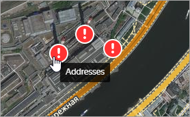
If the inaccuracy was registered more than 24 hours ago and has not been corrected, the point will be a red or an orange circle with an exclamation point inside.
Placemarks located close to each other are grouped together and the circle shows how many there are. To ungroup the placemarks, increase the map scale.
Note
If the inaccuracy has been dealt with (see below), the point will change to a green circle with a check mark.
2.11.2. Managing inaccuracies
-
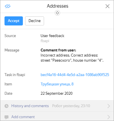
Click the selected icon. The report point will be highlighted on the map and its inaccuracy management card will open (the same goes for suggestions):
Note
Please note that the support staff may have received additional information for some of the inaccuracies and suggestions. If this is the case, the
History and comments
section of an inaccuracy management card will display an exclamation mark icon. This icon means that the message includes additional comments you should take a look at: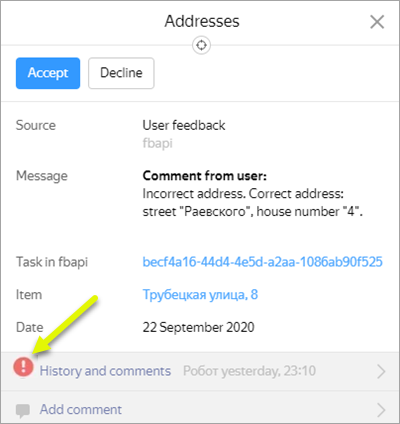
-
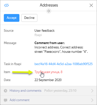
The inaccuracy cards list the following information:
-
Inaccuracy type (for example,
Addresses
).Note
Error reports and deletion requests create inaccuracies of the
Other (complex)
type, which are handled by cartographers: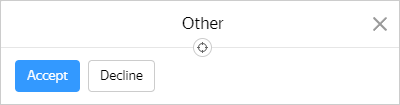
-
Report source (for example,
User feedback
). -
The report itself.
-
The Item link. Follow the link to open the corresponding item card (the card also includes the backlink to the report):
-
Movement type (usually found in inaccuracies related to routes).
The field indicates the type of transport correction is required for (car, pedestrian, bicycle, public transport).
-
Departure (usually found in inaccuracies related to routes).
The field indicates the departure time for which the user built the route.
-
An As drawn by the user link (for inaccuracies that involve places or routes).
The link points to the area on Yandex Maps that contains the places and routes the user drew. If the inaccuracy concerns an incorrect route, then the route builder's suggestion will appear as a blue dotted line, while the route suggested by the user will appear as a gray line.
If you're still unsure about what you're supposed to fix after looking at the map, don't accept the report.
-
An As seen by the user link (for errors that involve places or routes).
The link leads to the Yandex Maps area the user was looking at when they reported the inaccuracy. If that area doesn't match the YME area where the inaccuracy is supposed to be, the inaccuracy link is incorrect.
If you're still unsure about what you're supposed to fix after looking at the map, don't accept the report.
-
The message text and creation date.
-
An Add comments link. Click it to add a comment for the inaccuracy.
-
An Accept button. Click it if you decided to make a correction.
The inaccuracy will be assigned to you after you click the button: it will no longer be visible to other users and all further edits will be saved in the changelog.
If you decided not to make corrections, close the card by clicking Decline (or Close
 ).
).
-
-
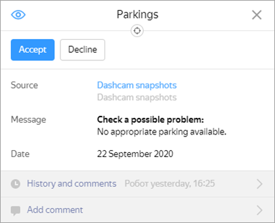
The inaccuracy suggestion cards list the following information:
-
Recommendation name.
-
Accept and Decline buttons (similar to an inaccuracy card)
-
Context — a link to the source that supports the user's hypothesis (for example, photos taken at the location).
If the recommendation is based on map data, the card will not contain a link.
-
The inaccuracy recommendation text.
-
Recommendation creation date.
-
Item — a link to the corresponding map item:
Note
In some cases, the card also contains information about the user's search query.
That is also useful information that needs to be taken into account and added to the data if possible.
-
-
-
If you click Accept, the recommendation card will look like this:
A Back to problem report button will appear next to the Create button: click it to return to the recommendation even if you've already closed its card.
Note
An edit counter will appear on the button as you manage the inaccuracy:

If the counter displays an incorrectly high number of edits (as shown in the drawing), then something probably went wrong.
Every inaccuracy management card has its own counter. The counter value will not reset, even if close the map and return later.
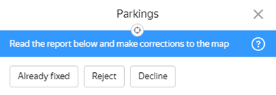
Inaccuracy management cards include these buttons:
-
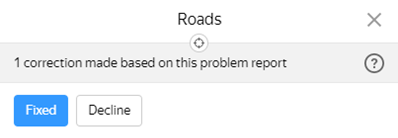
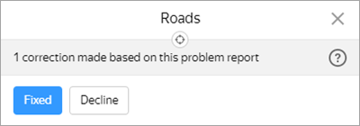
Already fixed — displayed when no edits are submitted for an inaccuracy.
-
Fixed by me — displayed when at least one edit has been submitted for an inaccuracy.
-
Reject — if you click Reject, the following message will appear on the card:
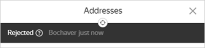
The inaccuracy marker will look like this

-
Decline — click Decline to make the inaccuracy visible to and accessible by other users. Other moderators will gain access to the inaccuracy in order to handle it.
-
-
Click Accept to enter inaccuracy management mode so you can edit the map. While in this mode, you will be unable to work on other inaccuracies (you will see a message that says
You're currently working on another inaccuracy
if you try).Once you accept the inaccuracy, its inaccuracy management card will close, but you will still see the Back to inaccuracy button as well as a counter for the edits you make.
-
Once you've made all the necessary edits, click Back to problem report.
An inaccuracy card will open and display relevant data, such the number of edits and the users who submitted them:
-
If you fix the inaccuracy, click Fixed by me.
The following message will appear on the card:
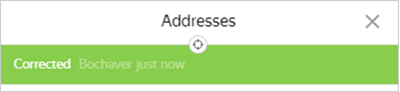
The inaccuracy marker will look like this

Once you finish woking on an inaccuracy, click Close
(or press Esc).If you feel that you need to make more changes, click Reopen.
2.11.3. Rules for submitting resolutions for inaccuracy reports and suggestions
You should only set a resolution in a problem report if you're absolutely sure the issue's been fixed. If you were unable to properly examine the report sent to you or the situation on site, please don't process the request. Let it be handled by another employee or map editor.
Resolutions should only be issued in the following cases:
Fixed by me
- Issued if:
-
The inaccuracy has been fixed by submitting an edit.
Note
You should issue a resolution even if the message pointed to the wrong coordinates but it was still possible to deduce what the requested item is and add it to the map.
-
This means that the inaccuracy indirectly helped update the data (even if the edited item is different from the item requested in the inaccuracy report).
For example:
- The route suggested by the user was suboptimal, but helped add missing roads to the map.
- The request for adding a missing address included the name of a street that was missing from the map.
-
Already fixed
-
Issued if:
-
The report covers a missing item that has already been put on the map in the correct location. The inaccuracy may be located at the same spot the item is, near the item, or just be directly associated with the item.
For example:
- The report covers a missing address that's already been added to the map, while the inaccuracy is located inside or near the building with the address specified in the report, or in the corresponding residential area sector.
- There are two identical inaccuracy reports that cover the same missing item. The first inaccuracy is resolved with the Fixed by me status and the corresponding item is then added to the map. The second inaccuracy is resolved with the Already fixed status and no edits to the map.
-
The report covers a sub-optimal route, but the all the proposed solutions are already added to the map, so the original reported route is added to the map instead.
-
Reject
-
Issued if:
-
The message contains spam with no useful or potentially useful information.
-
The report covers a missing item, but the Rules dictate that such an item should not be put on the map in the first place.
For example:
- Building entrance in a residential area
- Military facility
-
The report suggests a route that violates traffic rules.
For example:
- The report proposes a route that intersects with a railroad without an equipped crosswalk.
- The report proposes a route that intersects with a road without a pedestrian crossing, even though there is one nearby.
-
The report covers a sub-optimal route, but the all the proposed solutions are already added to the map and the route can be plotted on the map (for example, by adding an intermediate point).
For example:
- The existing route is longer than the one proposed by the map editor.
-
The information provided in the report is false. At the same time, you must be sure that the up-to-date information is correct (this means the information can be verified by up-to-date on-site photos or you can confirm it having lived/visited there).
For example:
- The report covers an incorrect building number, but you're sure the address is correct (for instance, if you live there).
- The report covers a missing item that has already been put on the map, but the coordinates point to a completely different location unrelated to the missing item.
- The report contains a typo that points to a wrong address due to specifying the wrong road type (Washington street/Washington boulevard) or the wrong building number order (Washington Street 2/48 instead of Washington street 48/2).
-
Inaccuracy suggestion has been submitted based on an item that has been incorrectly recognized in a photo or positioned incorrectly.
-
2.11.4. Examples of inaccuracy management
-
If the message states that a building was demolished, check this information. If you can confirm it, select one of these edit options:
-
If the building is visible on the satellite image (meaning the image is outdated), set Demolished as the value of the Condition attribute.
-
If the building is not on the image (i.e. the image is current), delete the item from the map.
-
-
If the message claims that road construction/sinkholes/lanes repairs, etc. are present, check this information. If you can confirm it, select one of these edit options:
-
For long-term (more than three months) construction works that will change the road's construction features , disable transport accessibility for all types of vehicles in the area under construction (see 3.3.2.3. Accessible for), assign them the
under construction
flag (see 3.3.2.11. Under construction) and downgrade the class toMinimal significance road
(see 3.3.2.1.7). -
For temporary (less than three months) road closures, seasonal pavement renovations, roadbed repairs, long-term repairs without changes to the road's structural features, and other situations that make it difficult or impossible to travel along these sections of road, please do not correct the inaccuracy (it will be corrected by Yandex employees).
-
-
If the message states that a street or address doesn't exist on the map, check this information. Make sure that the item is not included among the current data and enter it on the map.
-
If the message concerns a walking route:
-
In this case, you should generally draw the missing paths, rather than deleting existing ones.
-
You should not draw unofficial trails formed by people trampling down grass, making holes in fences, or other means that break the rules.
-
If all the roads necessary for building a route have already been plotted on the map, but a user is claiming that the route was incorrectly set, then make sure that all roads on that route are accessible to pedestrians.
-
Routes set by the route builder may not match routes suggested by users.
For example, a route that a user suggests that goes through a park may be longer than the one set by the route builder. We can finish drawing the park trails, but the route will be set in accordance with the shortest trajectory as previously.
-