3.13.1. Rules for drawing rapid transit items
The Rapid transit category contains lines and stations in metro and light metro systems, rapid trams, rapid transit buses, urban cable cars and monorails, funiculars and other systems that transport passengers and do not run along city streets.
Light-rail transport (LRT) systems have specific drawing rules.
3.13.1.1. Rules for drawing rapid transit line sections
When drawing rapid transit line sections, you must adhere to the following rules:
3.13.1.1.1
-
Techniques for drawing and editing rapid transit line sections are similar to the techniques for drawing and editing all linear items on YME (see these sections):
3.13.1.1.2
-
Rapid transit lines are a simplified representation of the entire route of the transport vehicle.
Only draw route branches if they have the same name or number as the main route. If the number or name of a branch is different, it's considered a different route altogether.
Alert
Don't draw map items that represent detailed track arrangements or rings used for u-turns.
Don't draw any additional rapid transit line sections that are not publicly available (such as service tracks that connect different branches, depots and their access tracks).
Use railway, tram track, and motorway items to draw detailed track arrangements, (depending on the type of transport).
3.13.1.1.3
- Don't draw metro lines on Yandex Map Editor that are under construction.
3.13.1.2. Rules for drawing rapid transit stations
When drawing rapid transit stations, you must adhere to the following rules:
313.1.2.1
- Use placemarks to represent rapid transit stations. Don't draw underground or ground-level station maps.
- Techniques for drawing and editing rapid transit stations are similar to the techniques for drawing and editing all places items on YME (see these sections):
3.13.1.2.2
-
Rapid transit station placemarks represent the stations themselves, as well as the stops that the transport vehicle makes there.
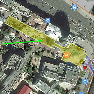
Placemarks for rapid transit lines should be placed in front of the station or the main station exit. If the exits are absent or hard to identify, place the placemark somewhere in front of the station's geometric center.
3.13.1.2.3
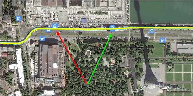
- Place rapid transit stations directly on the rapid transit line that they relate to. The green arrow in the drawing points to a station that was placed correctly; the red arrow — an incorrectly placed one:
3.13.1.2.4
-
Draw polygons representing a metro station (including those under construction) as Territory items of the Transport type:
3.13.1.2.5
-
Stations and exits that are abandoned or under construction are not indicated with placemarks.
Metro stations and exits that are closed temporarily (i.e. closed for renovation) can be left on the map.
3.13.1.3. Rules for drawing exits at rapid transit stations
When drawing exits from rapid transit stations, you must adhere to the following rules:
3.13.1.3.1
-
Put placemarks at the exits to rapid transport stations. Don't draw station exit maps.
-
Techniques for drawing and editing exits from rapid transit stations are similar to the techniques for drawing and editing all places items on YME (see these sections):
3.13.1.3.2
-
Don't draw exits from cable-car and funicular stations that operate at ground level.
If a station is fully or partially underground or has a closed-off area accessible only through a turnstile, all of its exits must be drawn as
Rapid transit station exit
placemarks (station halls, underground passageway exits, entrances and exits from the closed-off area, etc.)
3.13.1.3.3
-
If a station is located at ground level and the perimeter is not fenced-off, then put the "exit" at approximately the same location as the station itself.
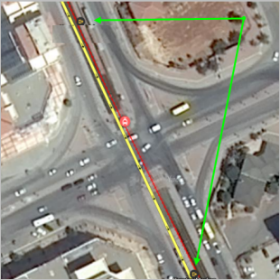
You can put two exit placemarks on the map if the station platforms are located on different sides of the road intersection:
-
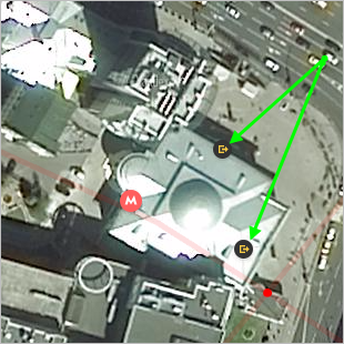
If the entrance and exit to a station lobby or pavilion are separate from each other (for example, they may be on opposite sides of the pavilion), then you can create separate placemarks for the entrance and exit.
For example:
3.13.1.4. Rules for drawing light rail transit items
One of the types of rapid transit objects is the light rail transit system (LRT) , which features high-speed trams and light rail (constructed similar to high-speed trams).
Alert
Whether a particular vehicle can be considered a rapid tram or light rail is determined on a case-by-case basis.
3.13.1.4.1. LRT systems
-
Draw LRT systems as rapid transit items (lines, stations, and exits from stations). Furthermore, rapid transit lines are duplicated by items of another category — tram lines.
Note
Track arrangements that are drawn as regular tram lines also include tram junctions and turning circles (see Section 3.14.1.1. Rules for drawing parts of tram lines).
3.13.1.4.2. Lines in an LRT system
-
LRT system lines are drawn as two objects:
-
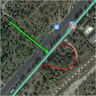
When drawn as rapid transit lines, make the lines smooth. Don't draw sharp turns or curves.
These lines approximate the transport system route the vehicle takes. They don't have to have a 1-to-1 correspondence with the actual path:
-
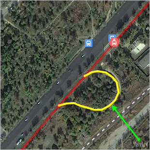
As Tram lines, they are drawn in accordance with mapping rules for regular tram lines (see Section 3.14.1.1. Rules for drawing parts of tram lines):
-
3.13.1.4.3. Stations and stops
- Draw stations and stops within LRT systems as rapid transit stations. Put the placemark directly on the rapid transit line in the approximate geographical center of the station. Also see Section 3.13.1.2. Rules for drawing rapid transit stations.
3.13.1.4.4. Station exits
-
If an LRT station is located at ground level, then put the "exit" at the approximate geometric center of the station itself.
If an LRT station is fully or partially underground, all of its exits must be drawn as
Rapid transit station exit
placemarks (station halls, underground passageway exits, etc.)