3.2.2. Rules for adding attributes to administrative divisions
- 3.2.2.1. Type (level)
- 3.2.2.2. Name
- 3.2.2.2.1 Official
- 3.2.2.2.2. For caption on map
- 3.2.2.2.3. Renaming
- 3.2.2.2.4. Synonym, historical
- 3.2.2.2.5. As part of the address
- 3.2.2.3. Administrative subordination
- 3.2.2.3.1. Country (level 1)
- 3.2.2.3.2. Area (level 2)
- 3.2.2.3.3. Regional area (level 3)
- 3.2.2.3.4. Locality (level 4)
- 3.2.2.3.5. The area of the city (level 5)
- 3.2.2.3.6. Named territory (level 6)
- 3.2.2.3.7. Blocks (level 7)
- 3.2.2.4. It is the center
- 3.2.2.5. Is a city
- 3.2.2.6. It is a municipality
- 3.2.2.7. Does not have an official status
- 3.2.2.8. Population
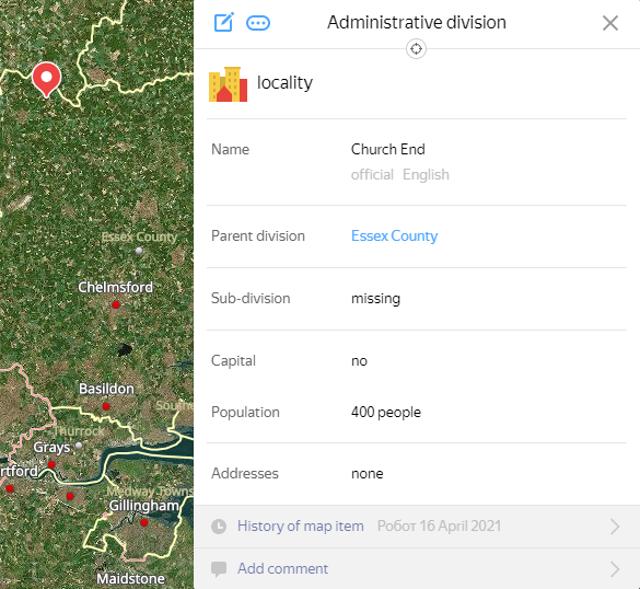
Use the attribute panel to add attributes to map items belonging to the Administrative division
category.
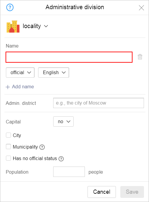
Rules for adding attributes to items can be found below.
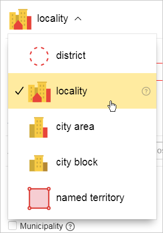
3.2.2.1. Type (level)
Choose the type (level) of an administrative division from the drop-down list in the upper panel:
Your choices for the type of administrative division will depend on the country you are mapping. Examples of second- and third-level administrative divisions (used in various countries) can be found in the table below:
|
Level 1. Country |
Level 2. Region |
Level 3. District |
|
Russia |
Region, republic, province, autonomous territory, autonomous region, federal city |
District, city region |
|
USA |
State |
Area |
|
Germany |
State |
Area |
|
Spain |
Autonomous region |
Province |
|
China |
Province, autonomous district, city municipalities |
County |
|
India |
State, federal territory |
Area, district |
|
Brazil |
State |
Municipality |
|
Australia |
State, territory |
County |
|
Poland |
Province |
Gmina, powiat |
|
Egypt |
Governorate |
Municipality |
|
Indonesia |
Province |
Region |
|
Belarus |
Region |
District |
|
Turkmenistan |
County |
District |
|
Georgia |
Province, autonomous republic |
District |
|
Turkey |
Silt |
District |
Note
Administrative divisions at the first level (Country
) and second level (Region
) can not be created or edited on Yandex Map Editor. They function solely as items that lower-level administrative divisions can be attributed to.
The available types of administrative divisions form a hierarchy: every division includes divisions of an equal or greater level within it. For more information, see Section 3.2.2.3. Administrative subordination.
3.2.2.2. Name
Rules for setting names are described in Sections 3.1.3.1. Name types: general rules and 3.1.3.2. Rules for entering all types of names.
Additionally, when you enter values for any of the Name
attribute types for various types of administrative divisions, you must follow these rules:
3.2.2.2.1 Official
This name type is mandatory.
The full name of the division that is officially recognized in that country.
It usually includes the type of map item if one is used and its spelling is known.
Rules for setting this type of names are described in Section 3.1.3.1.1. Official.
Note
For items whose names contain decimal fractions, separate the fraction from the integer in the official name with a dot.
3.2.2.2.2. For caption on map
Use this field if the item's caption on the map should differ from its official name.
Alert
This field is only filled in for the cases described by the rules.
Caption names typically do not include the map item type unless one of the following exceptions applies:
-
If map items of different sub-types (like a locality and a rural settlement) located nearby have identical proper names.
-
If map items are administrative divisions of levels 2 and 3.
-
If the proper name itself (without the type) is not sufficient to identify the item.
In these cases, the caption name should include an abbreviated type name.
For level 2 (Region
) and level 3 (District
) states, departments, municipalities, and provinces, don't include the type in the caption name.
Note
The name for caption of administrative divisions of the same name but different levels should not include their abbreviated type.
3.2.2.2.3. Previously called
See 3.1.3.1.5. Renaming.
3.2.2.2.4. Also known as, historical
See 3.1.3.1.6. Also known as, historical.
3.2.2.2.5. The address contains
Enter this name for administrative divisions if their address name differs from their official names. Also see Section 3.1.3.1.3. As part of the address.
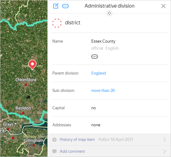
3.2.2.3. Parent division
The Parent division
panel indicates the administrative division that is one level above the item you are adding.
This is how the administrative division hierarchy is formed on the map.
Every division (other than those of the highest level: countries and administrative divisions of the same name that don't have an official status) should belong either to a division of a higher level or to a division of the same level that encompasses the item in question. If there are several divisions of the latter type, select the one with the smallest area as the parent.
Note
An exception to this rule is allowed when administrative units with the same name within the same division differ in that the parent division is supplemented or replaced in their addresses with a reference point that allows to identify each unit with the same name. The reference point can be of the same or higher level than the initial administrative division. For such units, the reference point is indicated as the parent division.
For example, if there are several gardening co-operatives with the name Luch
within the area, and their addresses are as follows: Luch gardening co-operative near Yav village and Luch gardening co-operative in Nav village, for the first object, the village of Yav should be set as the parent division, and for the second object, the village of Nav should be selected as the parent.
Thus, the position of the administrative unit in the hierarchy is not completely determined by the value of the attribute 3.2.2.1. Type (level): at the same hierarchy level there can be units with different attribute values, and vice versa: units of the same type can be at different levels of the hierarchy.
When administrative divisions of the same type belong to different hierarchy levels, it is referred to as division nesting.
Some items may have two positions in the administrative division hierarchy. For example, Moscow is both a level 4 (locality) and a level 2 (sub-federal unit).
Also note that sometimes levels can be skipped in the hierarchy. For example, a block (level 7) can have a parent division that is a level 4 "locality"
(for more information, see point 3.2.2.3.7).
- When viewing or editing parameters of administrative units, you can see the Sub-division section on the attribute panel. This section indicates the number of administrative divisions for which the current administrative division is a parent (in the form of a link to their list):
- Click the link to open the automatically generated list of subordinate administrative divisions:
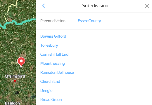
- Each line of the list is a link that points to the corresponding administrative division AD unit:
Yandex Map Editor has seven hierarchy levels for administrative divisions. Follow these rules when working with hierarchies:
3.2.2.3.1. Country (level 1)
Divisions at this level cannot be created or edited in Yandex Map Editor. They function solely as items that lower-level administrative divisions can be linked to.
3.2.2.3.2. Region (level 2)
Second-level administrative divisions can be nested.
Examples of second-level administrative divisions in various countries can be found in the above table.
Second-level divisions can not be created or edited on Yandex Map Editor. They function solely as items that lower-level administrative divisions can be linked to.
Note
There are a number of countries that don't have second-level administrative divisions. For these countries, districts are linked directly to first-level administrative divisions.
3.2.2.3.3. District (level 3)
District
is a general term that refers to districts that make up level 2 divisions: regions, provinces, republics, and autonomous areas. Municipal areas of Russia that are divided into urban and rural settlements, city regions in Russia, mayorats in Kazakhstan, and regional districts of various countries all belong to this level.
The parent division for districts is the region (level 2).
Level 3 divisions are the parent entities for individual Localities
(level 4) located on their territories.
Divisions at this level can be nested: for all urban/rural settlements (level 3), the parent divisions are the municipal districts they are located in (also level 3).
3.2.2.3.4. Locality (level 4)
This level of the hierarchy comprises officially registered localities that feature in the State Catalogue of Geographical Names or its analogues: cities, settlements, villages, and so on.
This level always includes gardening co-ops and rural (dacha)settlements.
In large and sparsely populated territories located far from urban areas, this level also includes individual homes that have names. A home like this is marked as a Center of administrative division (placemark, no polygons).
Note
This level also includes territories of former localities that still have addresses and streets (such as in the Chernobyl zone).
Level 3 (Districts
) map items are the parent urban/rural areas for these level 4 localities. If there are no urban or rural settlements, then the municipal district, city region, or level 3 administrative division units and municipalities in other countries that the locality is located in function as the parent item.
Level 4 items are the parent entities for Level 5 (City districts) and Level 7 (Blocks) divisions, with the exception of blocks of the same name located within one locality, which are linked to city districts to which they belong. Localities within other localities are also classified as Level 7 (Blocks) divisions.
You can nest items at this level: gardening co-ops, cottage settlements, and other items marked without official status
located in localities are subject to that locality. For example: город Пенза (4) → садовое товарищество Ивушка (4).
Building areas located within level 4 municipalities must be linked to municipalities that fully or partially cover their territory.
For gardening co-ops of the same name, a minimum administrative division that completely encompasses them is selected as the parent.
Localities on the territories of federal cities are classified according to their special rules.
In countries where lower administrative divisions (municipalities or localities) cover the entirety of their parent divisions, draw the contour of the actual development in addition to the legal border of the locality or municipality.
In this case:
-
A municipality or locality within its legal borders is used to form an address. Child districts, blocks, and streets are linked to it. The item is marked as
Municipality
. -
If necessary, the
City
andCenter of district, region, country
attributes and the number of residents are carried over to the development area. The locality or municipality within which the development area is located is set as its parent division. The development area can only be set as a parent for named territories.
Both items are drawn at level 4 (except for municipalities of cities with the country as their parent, which are mapped as level 2 items). According to the rules for drawing the center of a locality, they are placed as close to each other as possible. If the municipality is completely built up, both items are created within the same borders.
3.2.2.3.5. City district (level 5)
City districts have their own hierarchical level separate from that for subdistricts and blocks.
For city districts, an administrative unit of level 5 (City district), level 4 (Locality), or higher with the smallest area that fully covers this district (namely, a larger city district or locality) is selected as the parent.
City districts are the parent entities for blocks of the same name located within one locality.
3.2.2.3.6. Named territory (level 6)
This level of the hierarchy includes:
-
Unofficial territories within localities that have borders and established informal or historical names (i.e. the name doesn't adhere to any classification system, but is rather a proper name).
-
Anthropogenic terrain (former localities or agricultural areas) bearing traces of human activity that can be identified and still serve as landmarks, such as dilapidated buildings, remnants of former vegetable gardens, boundaries between plots of land, and so on.
Note
Similarly uninhabited areas that still have addresses and streets (such as the Chernobyl zone) are classified as localities (level 4).
-
Terrains that are previously inhabited areas where structures are physically missing, no economic activity takes place, and the territory of anthropogenic influence cannot be discerned via satellite imagery.
If a vegetation, hydrography, or terrain item currently bears the name of a terrain like that, create the terrain in the corresponding Vegetation, Hydrography, or Terrain layer.
-
Territories of advanced socio-economic development.
-
Intersections and interchanges with established names (all countries except Turkey).
Note
If an item's name is derived from its location or names of the roads in the area, it is not considered proper name.
Intersections and at-grade junctions are represented as a placemark with no polygons on the map. For example,
Pyat Uglov
in St. Petersburg: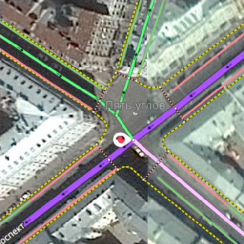
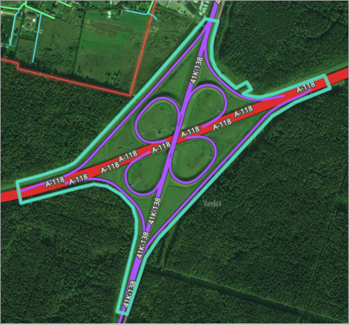
Junctions at different grades should be drawn with polygons if they have proper names. The polygon should include the junction and part of its nearby territory if that area historically shares the junction's name. For example:
Enter an Official
name for these types of territories (even though they don't have official names per se, which their level classification attests to).
Nesting of named territories is not allowed: parent divisions for level 6 items must belong to a higher level of the hierarchy. Even in cases where the named territory (level 6) is located in an unofficial district that is also a level 6 item, the locality is still the parent item for both of them.
Example: Dolgoe Urochische in Voskresensky District..
Level-six items cannot have child items. You cannot attribute addresses and roads to level-six items.
3.2.2.3.7. Blocks (level 7)
This level of the hierarchy includes:
-
Former villages, hamlets, settlements, towns, and cities that are no longer official localities but whose names are used in addresses.
-
Former villages, hamlets, settlements, towns, and cities that are no longer official localities and whose names are not used in addresses but that still have standalone structures and landmark value, or that still have structures or traces of economic activity.
-
Residential areas, towns, and villages located on the territory of localities that do not have an official status but are referenced as citywide landmarks in official documents and used in transport stop names, media, and advertising (by officially registered mass media organizations and advertising agencies). If you are not sure what an item's type is, give preference to whatever one is used in local government documents.
-
Architectural planning divisions that have the
subdistrict
orblock
types in their names may be located within localities or outside of them. -
Named individual homes and small khutor-type structures that have no other address indication other than their proper name. Also see point 3.2.1.4.5.
Note
Named residential homes in broad and sparsely populated areas are an exception. For details, see paragraph 3.2.2.3.4.
-
All residential complexes (and their analogues), blocks, and groups of buildings with three or more stories that have their own branded names and typically:
- Share a common architectural and planning style.
- Are fenced off from the surrounding buildings.
Note
On the territory of the former USSR, buildings with proper names that are not architectural landmarks and meet the above-mentioned requirements are marked as objects of administrative division level 7.
For example:
Official: Vega Residential Complex, Parus Residential Complex, Gamma Building, London Building.
For map caption: Vega, Parus, Gamma, London.
Note
You can map brand names of residential complexes found in the internet search results, even if the name looks like a descriptive one.
For example: Time Warner Condominium, Gazprom Residential Complex.
-
Shift workers' settlements, territories of sports complexes (including ski bases, race tracks, motorcycle tracks, and sports fields), recreation areas (resorts, country hotels, wellness centers), industrial parks, factory clusters, and active military cities that contain named passageways and addresses within the item as well as territories of organizations (such as garage co-ops) giving unofficial names to streets or addresses, provided the names are confirmed by the map, signage, or a resolution of the organization. The streets and addresses do not have to be visible on the map.
-
Descriptive administrative division units if the name of such administrative division units is featured in official documents and also other sources (for example, news websites or organization websites) as the address of an organization that has no specific house number. In addition, this organization must be specifically involved in receiving external visitors (for example, hotels, sports complexes, or campsites).
In this case, set the boundaries of the descriptive administrative division unit according to the territorial boundaries of the organization that contains that administrative division unit in its address.
For blocks, an administrative unit with the smallest area that completely encompasses that block is selected as the parent (except for those of the City district and the Named territory types). The exception is blocks of the same name located within one locality that can't be linked to an administrative unit with the smallest area. These blocks have city districts (level 5) as parent items instead.
3.2.2.4. Center
If the administrative unit is not the administrative center, leave the default value in the field.: No
(according to local laws, it is not an administrative center).
If the division in question is the administrative center, then select its hierarchical level from the list:
-
Countries — capital of the country.
Note
There can only be one locality with the
Center: country
attribute on the territory of a state. -
Region — administrative center of a region, province, territory, or republic (see Section 3.2.2.3. Administrative subordination).
-
Regional district — administrative center of a regional, municipal, or urban district (see Section 3.2.2.3. Administrative subordination).
The regional district center attribute can only be set for localities that are centers of level 3 (Regional district) divisions subordinate to divisions of level 2 (Region) or higher.
City districts classified as level 3 (Regional district) divisions can also be set as regional district centers.
3.2.2.5. City
If an administrative division of the Locality
type is a city, then check the box in the City field.
Note
For the US, only check the City box for centers of municipalities and administrative divisions of higher levels.
3.2.2.6. Municipality
Use the box in the Municipality field for countries where municipalities or localities cover the whole parent area and there are no other independent official localities within the borders of these items.
Such administrative division units are the parent items for all elements with addresses within them (such as streets, blocks, farmsteads, neighborhoods, individual addresses).
Even though these municipalities are not officially localities, they should be assigned to the Locality
hierarchy level.
For example, communes in France, quarters in Turkey, etc.
In other cases, do not check the box.
3.2.2.7. Doesn't have an official status
Check the Has no official status box for administrative divisions of the following types:
-
Locality
: gardening co-ops, village cottages, rural settlements, standalone buildings, or groups of buildings that have proper names, as well as other individual localities that are not included in official locality databases.For example:
-
Gardening or dacha co-ops and all types of associations, gardening plots, and similar map items — Berezka Gardening Non-profit Partnership, Rus Co-op
-
All cottage settlements — Ravissant Cottage Settlement
-
Free-standing homes groups of homes that have proper names; fishing villages in the Baltic States, cabins in the Extreme North and similar map items — Slavnoe Settlement, Mirnoe Ancestral Estate, Bovanenkovo Base Camp, 1038 Kilometer Home, 7031 Kilometer Railway Barracks
-
-
Block
:- All residential complexes and buildings with proper names
- Blocks that are part of localities with the Doesn't have an official status option enabled
- Territories of organizations that use unofficial street names or addresses for navigation, including garage cooperatives, even if data about them can be found in official address registers.
Alert
Don't check the Has no official status box for any other administrative divisions.
This includes items of the named territory
type: by definition these items already have no official status.
3.2.2.8. Population
The term "population" refers to the number of registered inhabitants in a given locality or other administrative division. Use statistics published by state agencies or found on the official sites of local administrative entities to determine what the population of an area is.
Don't fill out the Population
field for gardening co-ops, or rural (dacha) settlements that do not have permanent registered residents (or for which there is no data available).
Note
In countries that are divided into municipalities, specify the population size in the municipality item attributes. Duplicating this information in the level 4 place card (Locality
) is also acceptable.