3.18. Indoor maps
Indoor maps are used to design and display layouts for buildings with multiple levels on Yandex Maps (railway terminals, airports, shopping malls, business centers, and others).
Note
In Yandex Map Editor, indoor maps are drawn when the following conditions are met:
- At least one of the floors of a building (for example, a shopping or business center) has indoor areas people visit.
- At least one floor of a building, such as a shopping mall or business center, has five or more units (ten or more for residential buildings) that share the same name, are used for the sale of goods or provision of services, and are accessible through a single entrance.
These conditions don't apply to transportation facilities.
For example, here is the map of the second level (floor) of Terminal D of Sheremetyevo Airport:
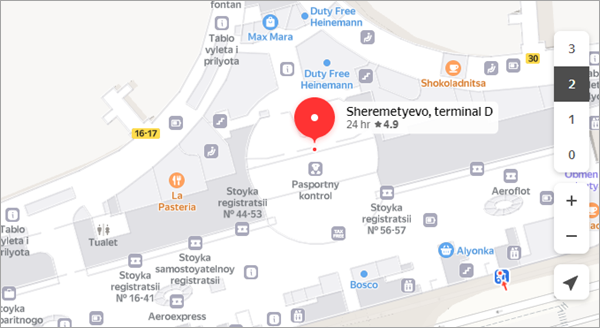
Such maps have a hierarchical structure: each indoor map is tied to the building's layout and divided into levels. Levels usually match the floor plans and correspond to the building's floors. Each level (floor) is divided into areas of different types. Each level can include barriers, amenities (elevators, stairs, fountains, etc.), information items (such as information boards), and places (businesses) of different types.
Note
Indoor maps do display emergency elevators and don't display service elevators.
The rules for drawing and adding attributes to indoor maps are given in the following sections:
Alert
In the current version, users can't create indoor maps. New maps are created upon request (see Requests for indoor map creation).
We're currently accepting requests for indoor maps for shopping centers, railway terminals, and airports.
Before publication, items on indoors map may be marked and attributed inaccurately.