Types of transport
Yandex Maps plots routes for different types of transport. To view and compare all available options, plot a route and tap  .
.
Start plotting a route and select the appropriate transport type:
 — Car
— Car — Public transport
 — Taxi
 — On foot
 — Bicycle
 — Scooter
The features of each option are described below.
Car
In the app, you can plot routes for passenger cars. Such routes take into account various road restrictions, such as weight limit signs or speed limits.
Set the route parameters:
- Exclude toll roads
-
Tap
 and enable the Avoid toll roads option.
 - Exclude poor quality roads
-
Tap
and enable the Avoid bad and unpaved roads option.
- Select the departure time and date
-
- Tap
 at the bottom of the screen.
 - Select the date and time.
- Tap Done.
The route will be updated taking into account the specified parameters. To reset the route for the current time, tap Reset at the bottom of the screen.
To start moving along the route, tap Go. The travel time will be recalculated.
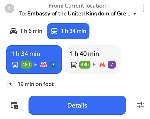
By public transport
- Select transport types
-
- Tap at the bottom of the screen.
- Choose the preferred transport types.
- Tap Done. Yandex Maps will prioritize routes with your selected transport type.
- Select the time and date of departure or arrival
-
- Tap at the bottom of the screen.
- Select Departure or Arrival.
- Select the date and time.
- Tap Done.
The route will be updated taking into account the specified parameters. To reset the route for the current time, tap Reset at the bottom of the screen.
Combined routes
Yandex Maps can plot combined routes comprising multiple modes of transportation to shorten the travel time.
For example, this is useful when your route starts far from the nearest metro station, and walking or taking a bus there would take too much time. In this case, Yandex Maps will suggest calling a taxi to the metro station, from where you can continue by public transport.
Yandex Maps won't suggest a combined route if you're very close to or very far away from a metro station.
Comfortable routes
In cities with extreme weather conditions (high temperatures in summer and low in winter), Yandex Maps can plot comfortable routes for public transport and for pedestrians. There may be several comfortable routes, and sometimes they aren't the fastest.
When plotting a route, you'll see these icons on the map:
 — The route goes through public transport stops or covered pedestrian crossings with air conditioning
 — The route goes through heated public transport stops
You won't see comfortable routes if the weather isn't too hot or cold.
By taxi
If you wish to travel by taxi, you can:
- Select a service class.
- Select a payment method.
- Set additional parameters, such as a comment to the order. For more information, see Taxi.
After selecting the parameters, tap Order a ride to make the app start searching for an available car.
View taxi orders in Yandex Maps
If you order a taxi in Yandex Go, it'll be displayed in Yandex Maps in Navigator mode.
At the bottom of the screen, you'll see the order information: car make and license plate number, and the estimated arrival time. Tap on the order to see the details.
On foot
), you can always change your mind and book a taxi. To do this, just tap  .
.The route may display terrain info which includes the number of steps and changes in height. Steep climbs are highlighted in red.
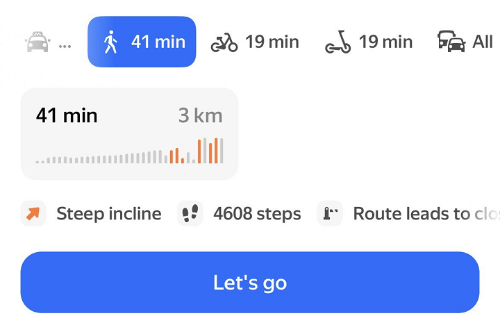
Terrain info is shown for some cities of Armenia, Belarus, Kazakhstan, Russia, Serbia, and Türkiye.
If there's insufficient data about elevation changes, you won't see the terrain info.
By bike or scooter
Route sections are highlighted in different colors:
- Green indicates a bike path or a sidewalk.
- Purple indicates roads with traffic.
- Gray indicates a closed area.
The app also shows the number of stairs on the route.
The route may display terrain info which includes the number of changes in height. Steep climbs are highlighted in red.
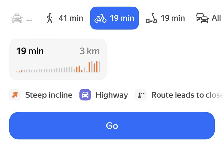
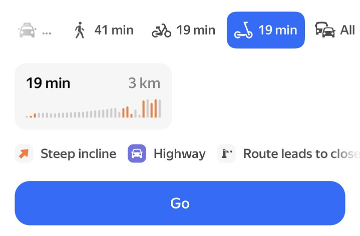
Terrain info is shown for some cities of Armenia, Belarus, Kazakhstan, Russia, Serbia, and Türkiye.
If there's insufficient data about elevation changes, you won't see the terrain info.
- Scooter etiquette
-
You will see the Scooter etiquette: ride safety message when you first plot a scooter route. Tap Learn more and study the tips. After that, the message will disappear.
